
Walks in Honeybourne
Honeybourne is surrounded by beautiful countryside and has a rich history to discover on foot. Below you’ll find details of local circular walks, with more to be added over time.
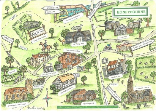 Walk 1: Tales and Trails — A Circular Walk Around Honeybourne Village
Produced by Friends of Honeybourne Station
Distance: 2.5 miles
Time: Approximately 1 hour
Terrain: Flat, no stiles, mostly good footpaths (may be muddy after wet weather)
Starting from Honeybourne Station, this gentle circular walk takes you through the village and surrounding countryside, passing many of Honeybourne’s historic landmarks — including the site of the former RAF Honeybourne airfield, St Ecgwin’s Church, Cow Honeybourne Church, the Thatched Tavern, and the site of the former Honeybourne Sheep Sale.
Along the way, you’ll discover stories about the village’s railway heritage, its Roman and Saxon origins along Buckle Street, and the farming history still visible in the landscape today.
Download the full walk leaflet with map directionshttps://honeybourne-pc.gov.uk/wp-content/uploads/2026/07/CIRCULAR_WALK_1_A5_4.pdf
 Walk 2: Honeybourne Walk — A Circular Walk Towards Bretforton
Distance: 3 miles
Terrain: Flat, with 3 stiles
The walk starts at the footpath adjacent to Maple Close off the High Street. After 50 yards turn left into the corner of the field and cross the ditch bridge. You will pass alongside the underground sewage pumping station before crossing over a stile. Wa lk diagonally across the paddock and through the gate. Walk across the farmyard and through the next gate; into the next paddock and onto the gate at the far end. Take care to follow the waymarker on the gate post that directs you in the general direction of the brook on your right-hand side. Over a stile in the middle of the field and onwards, passing a dismantled stile, to the bridge over the Gate Inn brook.
Turn immediately left as you leave the bridge, and continue to follow the brook; through the large field gates, and continue to follow the brook until you meet another pair of large field gates leading back over the brook. Through the gates and you are now on the bridleway that passes through the gap in the field hedge opposite, and then follows the edge of the field until you reach the Bretforton Road.
Take great care when crossing the Bretforton Road. This is a very fast road and visibility is not very good. Once across the road, follow the verge to your right. You will see an ancient county boundary stone (Worcestershire / Gloucestershire) near the hedge. Take the first track on your left (signpost is on opposite side of the road). Follow this track with the hedge on your left. After 200 yards the path moves across so that the hedge is now on your right.
Through the gap in the hedge and into the next field (full of poly-tunnels) where you will immediately fork right and follow the path between the strawberry tunnels. Immediately after the tunnels, turn left (almost back on yourself) to head back in the direction of Honeybourne, again between the strawberry tunnels. After the last strawberry tunnel walk into the corner of the field where you will find a bridge across the ditch into the next field. Immediately turn right and, after 15 yards, you will turn left onto path to the other side of this field. Turn right at the waymarker post and follow the field edge to the next waymarker post where you will turn left into the next field. Follow the edge of this field until you meet the Bretforton Road again. Take great care. Turn right towards the village and down the High Street back to your starting point.